|
Background
After we started Geocaching we heard about hunting benchmarks. Benchmark hunting
uses a mixture of urban archaeology, instruction translation, GPSr navigation,
and digital photography to seek and log benchmarks. This page describes the
basics of Benchmark Hunting.
Equipment
The equipment we use for Benchmark hunting is a little more varied than our
Geocaching equipment. We still use a GPSr (primarily to verify the benchmark
location), but we also use a tape measure (to measure distances from objects), a
digital camera (to record the benchmark and benchmark area), a compass (to
identify directions when taking pictures), a wire brush (to clean the
benchmark), a small trowel (to dig for the benchmark), and long thing screw
driver (to probe for the benchmark). I’m sure as we continue new pieces of
equipment will be added to our pack.
Where are the Benchmarks?
We primarily use
geocaching.com to identify the
benchmarks we want to hunt. The site provides a lot
of information about Benchmarking, like: how to get started, descriptions and location
of benchmarks in the United States, forums, etc. We also use the
National Geodetic Survey
(NGS) Datasheet Page to get current information about the benchmarks we want to
find. The next sections give you quick
overview how to use the geocaching.com and NGS
sites to find and log benchmarks.
Get a geocaching.com account
To actually get the coordinates for benchmarks you need to sign up for a free
account. To create an account you need to click on the
log in hyperlink located at the site. If you are just starting out you
probably don't need to sign up for a Premium Membership until you decide you
actually like Benchmark hunting and want the additional features the you get with a
Premium Membership.
Get local benchmark information from geocaching.com
Once you get your account you'll probably want to see what kind of benchmarks are
near where you live. After you log in you can look on their Home Page and under
"Find a Benchmark..." you can enter your zip code. When you select Go you'll
get a page something like this:
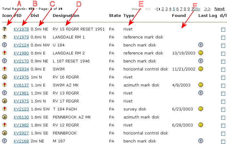
The "A" column indicates the status of the benchmark. A
 indicates that the mark has been officially reported as missing in the NGS
database, a
indicates that the mark has been officially reported as missing in the NGS
database, a
 indicates that someone from geocaching.com could not find the benchmark, a
 indicates that someone from geocaching.com has found the benchmark, and a
 indicates a benchmark that has not yet been searched for by someone at
geocaching.com. The "B" column identifies the Permanent Identifiers (PID) for the
benchmark (the NGS database key for the benchmark), the "C" column shows you how far and what direction the
benchmark is from your
location. The "D" column identifies the benchmark designator (if the benchmark
inscription, this would be what is inscribed on it). The "E" column identifies
the type of benchmark, and the "F" column identifies the geocaching.com
found/not found status.
indicates a benchmark that has not yet been searched for by someone at
geocaching.com. The "B" column identifies the Permanent Identifiers (PID) for the
benchmark (the NGS database key for the benchmark), the "C" column shows you how far and what direction the
benchmark is from your
location. The "D" column identifies the benchmark designator (if the benchmark
inscription, this would be what is inscribed on it). The "E" column identifies
the type of benchmark, and the "F" column identifies the geocaching.com
found/not found status.
How to read a benchmark page on geocaching.com
For your first benchmark you probably want to pick one that is near your location,
is a survey disk, and has been found by someone from geocaching.com. The
benchmark KV6137 "SWIM AZ MK" meets all of these
requirements. If you click on KV6137 you should
see something like this:
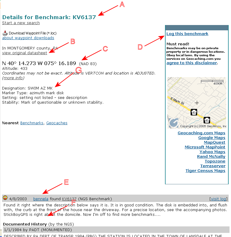
"A" points to the PID, "B" is a link to a entry for this benchmark in the NGS
database, "C" points to the coordinates you would enter into your GPSr
(notice it uses a NAD 83 datum), "D" points to the link that you can use to log
your find, "E" shows the log entries from geocaching.com users, "F" details
the instructions to reach the benchmark, and "G" identifies the designator of
the benchmark.
You need to select the datasheet (at "B") or look at "F" to obtain the
instructions to the benchmark. You should not rely on the coordinates ("C") to be
completely accurate (many benchmarks were placed before the GPS was deployed,
so the coordinates are sometimes estimated).
Logging your find at geocaching.com
When you search for a benchmark you
should record your results (found, not found or destroyed) at the geocaching.com
web site. Here are some guidelines for the three categories:
-
Found - your found the actual
mark! Since there can be other benchmarks near your benchmark you should
ensure the mark on the benchmark is the same as what's identified in "G". When
you find a benchmark you should take a close-up picture of the mark and a
picture of the surrounding area (to help others locate the mark in the
future). Also include any notes that would update the instructions to the mark
(like road name changes, distance changes, etc.).
-
Not found - you couldn't find
the mark, or you think it's missing/gone/buried/etc. Sometimes the directions
to the mark are not clear, or the area has changed and the mark may be buried,
covered, etc. When you make your log entry describe where you looked and take
a picture of the area. The entry may help you or others who may return to the
site to attempt to try to find the benchmark in the future.
-
Destroyed - only use this
designator if you have evidence the benchmark is destroyed (you found it in a
concrete base pulled from the ground, or it was supposed to be in a tower or
other structure that has been destroyed). Do not use this designation if you
think it may just be buried under some dirt or a road. Take a picture of the
removed mark, or the area where the structure used to be. It can also be
helpful to include any news articles describing the destruction of the
structure.
The NGS PID database
The current status of the benchmarks that are in geocaching.com can be found in the
NGS PID database. If
you use the link to the database and enter "KV6137" you'll get a page
something like this:
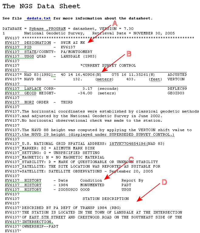
"A" points to the benchmark designator, "B" identifies the coordinates of the
benchmark, "C" identifies the status and history of the benchmark, and "D"
details the instructions to get to the benchmark.
Logging your find with the NGS
In addition to logging your results at geocaching.com, you can
also submit your findings in the
NGS Mark Recovery page. Professional surveyors, engineers, planners, etc.
use this database, so if you want to log your findings in this database please
be sure to be as accurate/precise as possible. Also note that there is no need
to make a new entry in the database unless the previous entry is more than a
year old, or you found a previously "Not Recovered" benchmark, or you have
evidence of a Destroyed benchmark. Here are some quick instructions for filling
out the form:
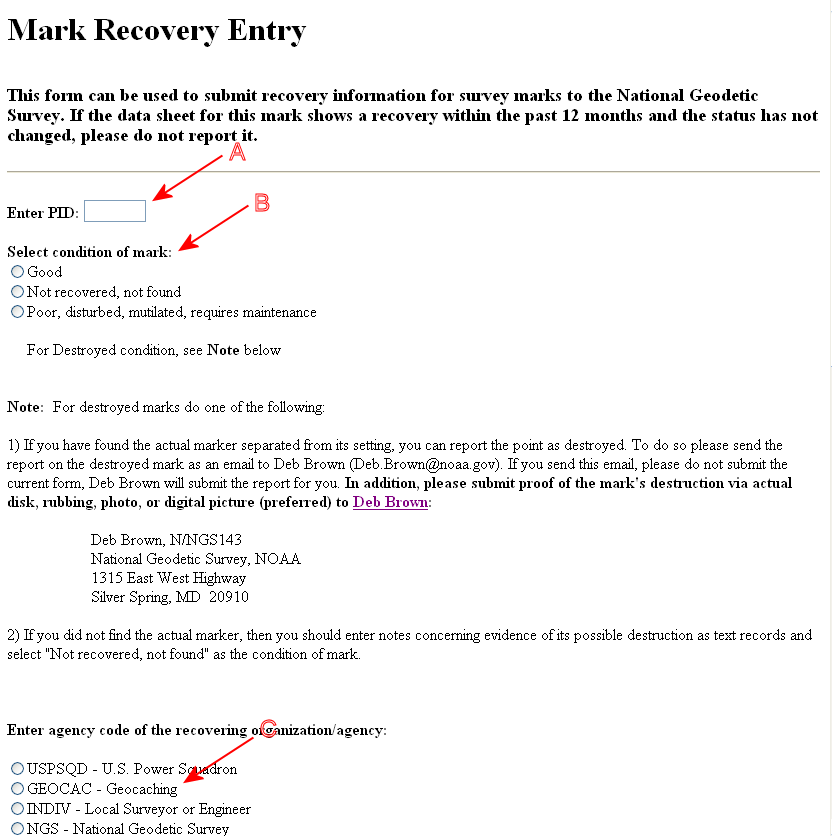
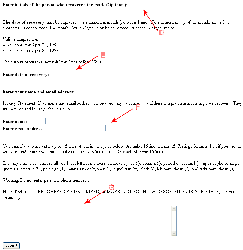
For "A" you enter the PID from the NGS Datasheet ("A"), "B" is
the condition of the mark (note the special attention for Destroyed), you can
select GEOCAC for "C" - this will also be recorded in the NGS Datasheet (at
"C"), if you enter your initials in "D" they will be recorded in the NGS
Datasheet (at "C") , "E" is the date (note the format), "F" is you name and
email address (note why they ask), "G" is any additional information you want to
provide in the database, like the road name changed, the distance has changed,
etc. - these comments will be entered in the NGS Datasheet (at "D").
After hitting Submit, and verifying your PID, you will be asked about satellite
coverage:
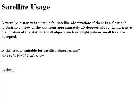
Answer the question based on your observations. You can look at
the the NGS Data Sheet for a suggestion about Satellite Observations from the
last log entry. If you are not sure then select "Don't know".
Other resources on the Internet
See the Geocaching page for additional
recourses.
If you have any questions or comments about this page click
here to send
email.
Last Modified:
March 11, 2006 02:54:02 PM
|